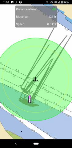
This is our "anchor watch" situation in an app called Aqua Map Marine. These tracks are since yesterday afternoon when the wind started blowing hard.
I positioned the anchor icon after anchoring so it is kind of a guess, but as we swing in arcs I can move it to the center of the arcs to be more accurate.
It goes off a couple times per night saying "BAD GPS ALERT, BAD GPS ALERT" which just means it has lost GPS signal. Usually it has figured it out by the time I wake up and pick up the phone, so that is annoying. Out bedroom is under the cockpit so it doesn't have great exposure to the sky. Fiberglass is pretty transparent to RF but there are some storage lockers with a lot of stuff in them and I bet the solar panels are good at blocking it.
The long straight lines are from when it gets an inaccurate reading, then a line is drawn back to our actual location as correct readings are put into what appears to be an averaging model. There is a time delay on the out-of-bounds alarm so I think only once has it actually alarmed when it is doing this behavior.
It runs in the background using the GPS continuously which uses up maybe 50% of the phone battery (Pixel 3A) in 8 hours.
- Log in to post comments